Prix FOB
Obtenir le dernier prix( Negotiable )
|1 Set Minimum Order
Pays:
China
N ° de modèle:
V30
Prix FOB:
( Negotiable ) Obtenir le dernier prix
Localité:
China
Prix de commande minimale:
-
Commande minimale:
1 Set
Packaging Detail:
gps receiver 50*27*44 cm weight: 13kg, total two box; accessories 145*38*22 cm, weight:6kg, one box
Heure de livraison:
1-2 weeks for the standard configuration
Capacité de Fournir:
10 Set per Month
Payment Type:
T/T, L/C, Western Union
Groupe de produits :
Personne à contacter Gloria
Zhenghua Road,Futian District, Shenzhen, Guangdong
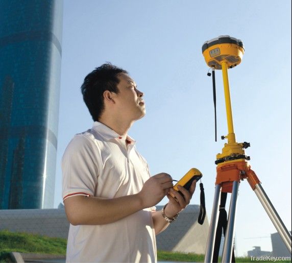
V*0 GNSS RTK SYSTEM
1. Built-in transmit-receive UHF, exchangeable Base and Rover.
2. The radio power is adjustable to be 0.1w, 1w, 2w.
3. 1+X multi-module communication units.
4. PCC Radio module (optional) compatible with Trimble/Leica RTK.
5. Double battery capacity as ***0mAh, *2 hours for RTK operating.
6. The highest performance in waterproof, dustproof and anti-drop.
7. Trimble BD**0 mother board, multi-satellite, multi-system kernel.
8. Supper long distance external radio(optional).
9. With the intelligentialized self-diagnosis function
*0. Config Multi-function RTK controller iHand1 series. Voice navigation of RTK handheld software.
The combination of the top GNSS industry’s technologies, V*0 gives you completely innovative user experiene.
Application:
Construction Lay Out
Abundant point and line lay out function, assistant by graph operation instruction, save your expenditure in practical construction.
Electricity and Transportation
Friendly function on power line route direction survey, distance survey and angle calculation; comprehensive survey functionality on road survey, center line, offset survey, profile and cross-section survey.
CORS Application
Seamlessly compatible with CORS system, only one RTK rover can receive CORS difference signal and carry out data collection, construction lay out work.
CORS Station Establishment
HD-CORS apply profound experience and mutual technology, stable on operation, long distance on data transmission, is your first choice for city continuous reference stations system.
Control Survey
Only one investment you can get list of function, v*0 dual frequency static survey accuracy can satisfy any requirements, config with mutual professional data solution software. You can easily accomplish various high precision control survey work.
Data conllection
Cotroller operation software designed for GIS application, convenient coding function, meets all your requirements in field data collection work.
Standard GPRS wireless data transmission unit
Technical Parameter
Technical specification of V*0
Signal trackingGPS: L1 C/A, L2E, L2C, L5
GLONASS: L1 C/A, L1 P, L2 C/A (restricted to GLONASS M) and L2 P
GALILEO:upgrade SBAS:WAAS,MSAS,EGNOS
Module technology:PCC Maxwell 6 advanced custom measurement GNSS technology
Extremely low-noise GNSS carrier phase measurements
Accuracy in the range of 0.**1m at 1 Hz bandwidth Mature low-elevation tracking techniques
Initializing time:<*0 s
Initializing reliability:>*9.9%
Positioning output:1Hz, 2 Hz, 5 Hz, *0 Hz, *0Hz and *0 Hz positioning output(*0Hz default)
Differential supported:CMR, CMR+, RTCM 2.1, 2.2, 2.3, 3.0, 3.1
Output format:ASCII:NMEA****3 and binary: Trimble GSOF
Positioning accuracy:Receiver accuracy
Static, rapid static accuracy :Horizontal: ±(2.5*1×***6D)mm Vertical: ±(5*1×***6D)mm
RTK positioning accuracy: Horizontal: ±(*0*1×***6D)mm Vertical: ±(*0*1×***6D)mm
Built-in communication:
Fixed GPRS module
Optional CDMA/3G network communication module
Optional CDMA communication services, WCDMA 3G communication function supported
Dual-mode network communication available,such as, GPRS+GPRS, GPRS+CDMA, GPRS*3G
Optional GM**6V built-in transmitter-receiver, V8 compatible
Emission power adjustable among 0.1W, 1W and 2W
Radio frequency bands **0MHz~**0MHz,offering **0 channels
Highest wireless communication transfer rate at *9.2Kbps
Optional GM**6PV built-in transmitter-receiver, imported radios compatible
Comply with RTK data transceivers of Trimble, Leica and other brands
Emission power adjustable among 0.1W, 1W and 2W
Radio frequency bands: **0MHz~**0MHz,offering *2channels, and users can customize the frequency table
Highest wireless communication transfer rate at *9.2Kbps
External radio:
Optional V8 radio
Radio frequency bands **0MHz~**0MHz,with the highest wireless communication transfer rate at *9.2Kbps, offering **0 channels,
Optional Lc**0 radio Emission power: 5W Radio frequency bands **0MHz~**0MHz,offering *4 channels
Optional UH****0 booster station
No external cable or battery is needed, so you can put it where you want within 5 kilometers away from the base station.
It can both directly transmit and forward in same-frequency or pilot-frequency
It has **6 UHF channels, and supports custom channels.
5W/*0W/*0W/*0W adjustable
Interface:Two RS***2 serial ports
Two external DC power port(reusable)
One Bluetooth wireless communications port
One USB port supporting data download
One GSM/CDMA SIM card compartment
Panel Key-Press and Indicator Lamps:3 panel key-presses, 1 power key-press, 2 function key-presses,
3 indicator lamps: one monochromatic lamp for satellites, one dual-color lamp for communications and one dual-color lamp for power
Physical Specifications:Memory *4M Main unit power: 2.5W Power : ***6 V DC
Battery system: Internal dual compartment Lithium battery system, each battery capability ***0mAh working up to *0 hours for GPRS mobile
station Size: φ*9.5cm×*0.4cm Weight: ***0g(with 2 batteries inserted)
Environmental characteristicsTwo meters water-proof, anti*3m natural drop,
completely dust-proof, IP*7 grade Operating temperature: **5°C~*5°C, Storage
temperature: **5°C~*5°C
Technical specifications of iHand *0 controller
| Pays: | China |
| N ° de modèle: | V30 |
| Prix FOB: | ( Negotiable ) Obtenir le dernier prix |
| Localité: | China |
| Prix de commande minimale: | - |
| Commande minimale: | 1 Set |
| Packaging Detail: | gps receiver 50*27*44 cm weight: 13kg, total two box; accessories 145*38*22 cm, weight:6kg, one box |
| Heure de livraison: | 1-2 weeks for the standard configuration |
| Capacité de Fournir: | 10 Set per Month |
| Payment Type: | T/T, L/C, Western Union |
| Groupe de produits : | RTK GNSS |


