Prix FOB
Obtenir le dernier prix|
1 Piece Minimum Order
Pays:
China
N ° de modèle:
X90
Prix FOB:
Localité:
China
Prix de commande minimale:
-
Commande minimale:
1 Piece
Packaging Detail:
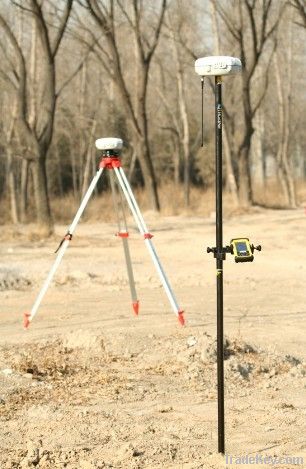
RTK base, rover
Heure de livraison:
5 working days
Capacité de Fournir:
1000 Set per Month
Payment Type:
T/T, L/C, Western Union
Groupe de produits :
Personne à contacter Mr. Leo
Longgang, Shenzhen, Guangdong
X*0 GPS Receiver GPS RTK Land Survey Equipment
X*0 GPS receiver, GPS RTK SYSTEM
The X*0 L1/L2 GPS system is designed to enable every surveyor to
access to high precision, robust performances and reliable
technology but without the common price constraints usually
associated with GPS investment. Fully scalable, the X*0 GPS various
configurations match a wide range of applications, from geodetic
post processing to survey grade network RTK.
Competitive and Reliable
The X*0 breaks the price barrier for cm accuracy positioning and
provides extremely quick return on investment compared to
equivalent GPS technology or traditional optical survey
equipment.
Oustanding Performances
The X*0 is powered by CHC patented GPS L1/L2 core engine and offers
outstanding accuracy and fast initialization (*0s typical) for
topographic surveying and stakeout. In geodetic applications mode,
the X*0 is able to process long baseline measurement up to **0 km
with the use of the Compass Office Software.
Cable Free
Built-in GNSS engine, antenna, Bluetooth® Communication and
optional GSM/GPRS modules in one single unit.
Compact and lightweight
The size of *0cm× 8.5cm (DxH) makes the X*0 only weight
1, 4 kg. It significantly reduces tiredness of the surveyors in the
field work.
X*0 GPS Specification
GNSS characteristic
. *4 channels:
- GPS: *2x L1, *2x L2
. Advanced multipath mitigation
. Optimized tracking for low elevation satellite
Performance specifications (1)
. Real Time Kinematics (RTK)
- Horizontal: *0mm*1ppm RMS
- Vertical: *0mm*1ppm RMS
- Initialization time: *0s
- Initialization reliability: Typical >*9.9%
. Post Processing Static and Fast Static
-Horizontal: 5mm*1ppm RMS
-Vertical: *0mm*2ppm RMS
. Post Processing Kinematic (PPK)
-Horizontal: *0mm*1ppm RMS
-Vertical: *0mm*1ppm RMS
Communications
. 1 RS**2 serial port
. 1 high-speed USB
. Optional GSM/GPRS modem
. Integrated Bluetooth ® Communications port
. Optional radio modem
- CHC DL3: 1W*0W adjustable (2)
- Bandwidth: *****0 MHz
. Protocols
- RTCM2.1, RTCM2.3, RTCM3.0, CMR and
Output
- RINEX and HCN outputs for GPS raw data
Physical
. Size (H× D): *5mm× **0mm
. Weight: 1.4 Kg without battery
. Working Temperature: **0 ° C to **0 ° C
. Storage Temperature: **0 ° C to **0° C
. Humidity: **0% condensation
. Dustproof: IP*7
. Waterproof: Protected from temporary immersion to
Depth of 1 meter, floating.
. Shock: Survive a 2 meters drop onto concrete
Electrical
. Typical power consumption: 2.8W
. Battery capacity: ***0mAh
. Operating times on internal battery: 6 hours (Static),
4.5 hours(RTK)
. External power : ***8VDC
Software
. Optional Landstar field software
-Intuitive and easy to use data field survey software
(logging, stake-out, site calibration, ^)
. Optional HPDiff field software
-Complete data collection solution for PPK field
Survey.
. Optional Compass and LandTour Office software
-Static and Kinematic post processing office
Software
-Combined ease of use and advanced data
Quality control.
| Pays: | China |
| N ° de modèle: | X90 |
| Prix FOB: | Obtenir le dernier prix |
| Localité: | China |
| Prix de commande minimale: | - |
| Commande minimale: | 1 Piece |
| Packaging Detail: | RTK base, rover |
| Heure de livraison: | 5 working days |
| Capacité de Fournir: | 1000 Set per Month |
| Payment Type: | T/T, L/C, Western Union |
| Groupe de produits : | GPS RTK Land Survey System |


