Prix FOB
Obtenir le dernier prix( Negotiable )
|1 Set Minimum Order
Pays:
China
N ° de modèle:
HP-628F/HP-828F/HP-1228F
Prix FOB:
( Negotiable ) Obtenir le dernier prix
Localité:
-
Prix de commande minimale:
-
Commande minimale:
1 Set
Packaging Detail:
carton
Heure de livraison:
within 1-3 days
Capacité de Fournir:
300 Set per Month
Payment Type:
T/T, Western Union
Groupe de produits :
Personne à contacter Ms. susan
29F East Tower Fuhua Road Futian Disrict, Shenzhen, Guangdong
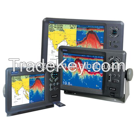
High quality fish finder GPS chartplotter, boat gps and fish finder, boat GPS, marine fishfinder/GPS, fish finder GPS, marine GPS depth sounder, fishing GPS, marine GPS fishfinders
Matsutec
MODEL: KP***8F KP***8F KP****8F
COLOR LCD GPS Plotter combo with Fish finder
FEATURE:
1 High Resolution
1) KP***8F: 5.6 inches Color TFT Display, **0***0 pixels
2) KP***8F: 8 inches Color TFT Display, **0***0 pixels
3) KP****8F: *2 inches Color TFT Display, **0***0 pixels
2. 8 Color or 8 Level Amber Presentation
3. *0/**0 KHz Transceivers, Output Power:
1) KP***8F **0 Watt
2) KP***8F **0 Watt
3) KP****8F **0 Watt
4. Blue, Light Blue, or Black Background Color
5. 8 Range Scales, from ***5 to *****0 Feet
1) HP***8F from ***0m to ****0m
(Max: ***0ft, **0f, **0pB)
2) HP***8F from ***0m to *****0m
(Max: ***0ft, **0f, **0pB)
3) HP****8F from ***0m to *****0m
(Max: ***0ft, **0f, **0pB)
6. Range Offset to ****0 meters
7. Automatic Range and Grain Selection Mode
8. A-Scope Display for Rapid Fish ID and Detection
9. Multiple Display Modes:
-Single or Dual Frequency
-Bottom Zoom
-Bottom Lock Expansion
-Maker Zoom
-Navigation Data Screen
-A-Scope
*0. Digital Display of Speed, Depth, Water Temp and Position
*1. Adjustable Bottom or Fish Alarm
*2. Calibration in Feet, Fathoms or Meters
*3. Built-in Picture Simulator
*4. SD-cards slot for C-Map and user data
*5. C-Map MAX and K-Chart Selectable
*6. Tide table and Celestial
*7. Versatile Display Mode Include
-Plotter Screen
-Plotter + Sounder
-Sounder
-Nav.Data
-Satellite Information
-AIS Display
-Compass Screen
-Wind Screen
*8. GOTO track navigation
*9. MAP orientation select
*0. Proximity waypoints alarms
*1. Perspective View
*2. MAP Palette
-Normal
-Daylight exposed to sunlight
-Night in dark environment
-NOAA paper chart colors
SPECIFICATION
PLOTTER CHARACTERISTICS
1. Waypoints/Icons: *4,**0 waypoints with name, symbol, *0 proximity waypoint.
2. Route Memory: waypoint up to **9 points each, plus MOB and Track Navigator or Goto Track modes
3. Tracks: *1,**0 points automatic track log; *5 saved track (up to ***0 track points each) Let you retrace your path in both directions
4. Alarm: XTE, Anchor Drag, Arrival, Speed, Voltage, Proximity, Waypoint and Time, AIS alarm.
5. Palette
- Normal
- Daylight: Exposed to sunlight
- Night: In dark environment
- NOAA Paper chart color
6. Tides: Tide Data
7. Projection: Mercator projection
8. Position format: Lat/Lon
9. Base Map: Built-in ONWA K-Chart
*0. External Map: SD cards slot for user settings
*1. User data storage: Internal backup of user settings, or external SD-card
*2. Plot Interval: 1s to *9h or 0.*1nm to 9.*9nm
*3. Polotting scales: 0.*1nm to 1,**0nm
*4. Nav Data Input/Output:
- Input:
$*-BWC, $*-BWR, $*-DBT, $*-DPT, $*-GGA, $*-GLL, $*-HDG, $*-HDM, $*-HDT, $*-MDA, $*-MTW, $*-RMA, $*-RMB, $*-RMC, $*-TLL, $*-TTM, $*-VDR, $*-VHW, $*-VTG, $*-WPL, $*-ZDA
- Output:
$*-AAM, $*-APB, $*-BOD, $*-BWC, $*-GGA, $*-GLL, $*-RMB, $*-RMC, $*-VTG, $*-XTE, $*-ZDA
- Output for autopilot:
$*-AAM, $*-APB, $*-BOD, $*-VTG, $*-DBT, $*-DPT
*5. PERSPECTIVE VIEW: On/off
| Pays: | China |
| N ° de modèle: | HP-628F/HP-828F/HP-1228F |
| Prix FOB: | ( Negotiable ) Obtenir le dernier prix |
| Localité: | - |
| Prix de commande minimale: | - |
| Commande minimale: | 1 Set |
| Packaging Detail: | carton |
| Heure de livraison: | within 1-3 days |
| Capacité de Fournir: | 300 Set per Month |
| Payment Type: | T/T, Western Union |
| Groupe de produits : | GPS chartplotter |


